michigan back roads
day trips and getaways
Michigan Copper Country Mystery
The Mystery
An estimated 500,000 tons of copper are missing from the Keweenaw Peninsula & Isle Royale. The copper was removed from pit mines which ranged from 5 to 30 feet deep. There are thousands of abandoned pit mines in the Keweenaw Range, more than 4,000 on Isle Royale alone. These pit mines were worked before 1,000 B.C. for a period of between 2,000 - 3,000 years. About ,1250 B.C. the mining activity stopped abruptly. These millions of pounds of copper are found nowhere in the North American archeological record.

Questions:
How deep were the mines? Who were the miners?
How did they smelt the ore before that technology was
widespread?
Where did the copper go?
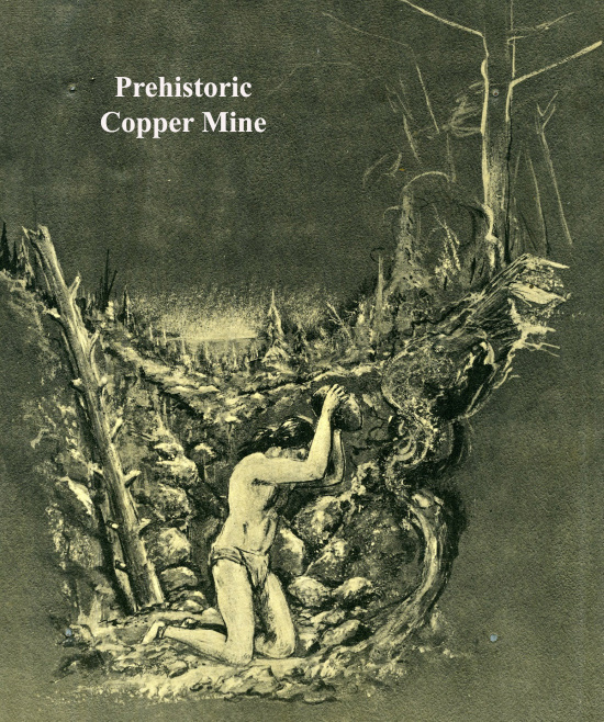
The prehistoric mines in question were pit mines 5 feet to 30 feet deep. It is known that indigineous people gathered float copper for ornamental purposes, points and trade. It is speculated that explorers may also have engaged in copper mining. It was not necessary to smelt this copper. The copper found in the Keweenaw Range is the purest on earth and can be worked in its raw state right out of the ground. Huge chunks of this pure copper were found right on the ground. It seemed that it had "floated" up to the surface, so it was called float copper.
 Enormous
slabs of copper were lifted out of the pits. Below is an image
of a piece of copper found still in a pit on Isle Royale resting
on an oak cradle. It was simply abandoned when the mines were
deserted around 1,250 BC. While it is not possible to test the
age of the copper, the age of the oak cradle was subjected to
carbon dating. It came out at around 1,400 B.C. The chunk of
copper weighs 6,000 pounds.
Enormous
slabs of copper were lifted out of the pits. Below is an image
of a piece of copper found still in a pit on Isle Royale resting
on an oak cradle. It was simply abandoned when the mines were
deserted around 1,250 BC. While it is not possible to test the
age of the copper, the age of the oak cradle was subjected to
carbon dating. It came out at around 1,400 B.C. The chunk of
copper weighs 6,000 pounds.
Enormous pieces of pure copper weren't the only things left behind when the miners left. At one pit mine alone, thousands of stone axes and hammers were found. It appeared that the miners had simply dropped their tools, left unfinished work and walked away.
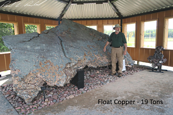
All mining activity ceased around 1,250 B.C. No one is sure exactly why mining ended across this vast region all about the same time. It wasn't because all of the copper had been mined, not even close. The Cliff Mine operated in the mid 1800s. 40 million tons of copper were mined there. Some slabs were so big, 50-100 tons, that they required days of cutting to get pieces small enough to transport. Many mines were started in modern times and, except for the White Pine Mine, all of them were opened on the site of a prehistoric mine. There was still a lot of easy copper to be found. Below is a slab of copper recovered from Lake Superior in the 1970s.
So, why did the mining activity stop so suddenly? Where is all that copper removed from these thousands of mines? The answer to both those questions may be the same, the Bronze Age. This period, approximately 3300 BC to 1200 BC, was characterized by the use of bronze, in some areas writing, and other early features of urban civilization. The demand for bronze in Europe and the Mediterranean was enormous. One order for the Roman Army required arms and armor for 100,000 men. Then there were tools, utensils etc.
The problem was, while tin was plentiful, copper was scarce and that which could be gotten required smelting and purifying. So, the Bronze age did happen, and bronze was produced on a massive scale. Where did the necessary copper come from?
One theory is that ancient mariners made regular journeys to the Americas to procure copper. The Phonecians record journeys lasting 3 years specifically to procure copper. Records suggest that both the Phoenicians and the Vikings arrived on the east coast of the Americas before and during the Bronze Age. The Phoenicians dominated sea trade in the Mediterranean Sea. The Mediterranean region produced vast amounts of Bronze and eventually lead the way into the Iron Age.
The Bronze Age - demand for workable copper - how was it transported before the discovery of the new world?

Some speculate that these people were not able to navigate the distance from Europe to the Western Hemisphere. In fact, the distance wasn’t a problem. The distance from one end of the Mediterranean Sea to the other is further than the distance from the bulge of Africa to South America. From there to the Gulf of Mexico and the Mississippi River is fairly simple.
To sail from Norway to North America can be done by short journeys to the chain of islands across the Atlantic. The journey from Norway to Northern England to Swalbard to Iceland to Greenland to Nova Scotia can be accomplished only being out of sight of land for about 2 days. From there to the St. Lawrence Seaway and the Great Lakes is fairly simple.
If we accept the idea that these maritime nations could make the journey to the Americas, is there any evidence that they made it to Lake Superior and the ancient copper deposits?
There is physical evidence that ancient mariners came to this region.
Hundreds of petroglyphs are found in limestone about
180-by-100 feet (a third the size of a football field) in
Peterborough, Canada.
Some have been interpreted as a record of an expedition to get
copper. Other glyphs record people in ocean going canoes
pursueing porpoises.
This petroglyph of a sailing ship is just a few miles from Copper Harbor at the tip of the Keweenaw Peninsula.

The MacIntosh Stone, found on the Keweenaw shoreline, depicts three men on oneside and a double hulled ship and a buckla on the other.

Enlargement

There are other artifacts in the area like the famous Kensington Rune stone.
One sticky problem with this whole theory is the absence of any permanent dwellings built by the miners and no shipwrecks of ocean-going vessels have been found anywhere in the region. Some say it is only reasonable to expect some ruins or wrecks if this mining activity was ongoing for thousands of years. How could so much copper be removed without towns, levees, docks and shipwrecks? This is Lake Superior after all, one of the most dangerous bodies of water on earth. How did ocean going vessels make their way to Lake Superior.
The explanation, though often overlooked, is fairly simple
and revolves around how the landscape was different in those
times and the existence of enormous canoes. There was no
necessity for permanent dwellings or huge docks and there was no
reason to try to get ocean-going vessels to Isle Royale. Those
big ocean ships simply waited at the coast for the copper to be
transported to them. There are a few ways it could work.
First, the mining season is short. There are only about 4 months
in this region when primitive mining could be carried out. Then
winter sets in. If most of the miners on Isle Royale were native
Americans, they simply bring teepees or build temporary bark
shelters and then leave them over the winter to be repaired and
used again come spring.
Moving the copper from Isle Royale to the mainland could easily be accomplished using canoes like this one.
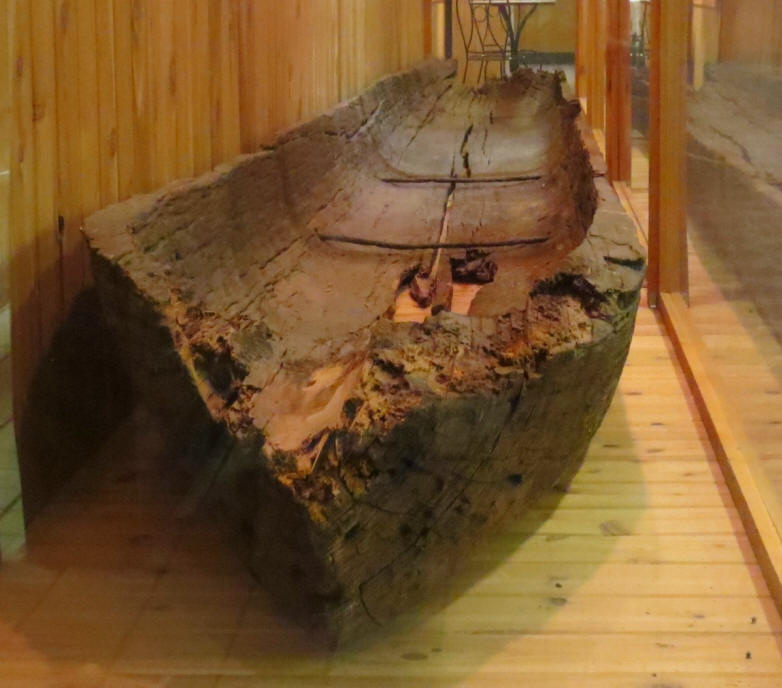
This canoe was found near Watersmeet in the 1950s. It is 32 feet long with 1 1/2 inch thick sides. It has a cargo capacity of 4,000+ pounds. A cube of copper 12 inches on a side weighs about 580 pounds. So, this canoe could carry a ton of copper and three men and all their gear. With the addition of an outrigger, this vessel is very stable.
There were several routes by which goods could be moved and traded between the north country and the rest of North America. Moving copper from Isle Royale along these routes, using several dozen canoes, means that hundreds of tons could be moved every mining season.
The overland route would be through Canada. It is only a few miles from Isle Royale to the Canadian mainland, then overland to Nova Scotia.
Copper could also be moved to mainland Michigan and beyond via canoe. The trip would take 10-12 hours, unless a sail was also used, to go from Isle Royale to the Keweenaw Peninsula. Traveling along the west of the peninsula the trip arrives at the Ontonagon River. Travelling up that river to a specific point leaves the travelers with just 2 portages to arrive at the Mississippi River. From there copper would be transfered to river rafts for the journey to the Gulf of Mexico. Michigan copper has been found all along the Mississippi, at Poverty Point in Louisana where vast smelting works operated, and all along the coast of the Gulf of Mexico.
Third and fourth routes would be along the north coast of the upper peninsula of Michigan. Way would lead either to the Straits of Mackinac, into Lake Huron and down to the St. Lawrence River and then up to the Atlantic. Alternately, the vessels could follow the shoreline and head south through the White Fish Gap. This was a waterway formed by a glacial burst ast the glaciers receded. That event formed a water passage across the uppe peninsula to Lake Michigan. From there travelers could make their way south and enter the river system near present day Chicago to make their way to the Mississippi River.
This map shows the White Fish Gap in red. The gap no longer exists due to isostatic, but the White Fish River follows the same course.
Copper was formed into oxhide ingots weighing 20-30 kilograms
each. This form made them easy to carry and they could be
stacked in the hold of a ship and used as ballast for the
journey. As copper was mined it was moved to collection areas
for transport by larger boats for transfer to the coasts and was
held there until ocean going vessels arrived to pick it up.
One such collection area was at Houghton on the Keweenaw
Peninsula. During work to develop the harbor there, a cache of
20,000 pounds of worked copper was discovered.